
NASA, the Internet, and Education Working Together
NASA, the Internet, and Education Working Together" The Technology Source, January 1999. Available online at http://ts.mivu.org/default.asp?show=article&id=1034. The article is reprinted here with permission of the publisher.
Space...the final frontier. These words opened each episode of the popular Star Trek series. An infinitesimally small number of people have actually ventured into space; we earth-bound folks can only dream of what it's like to be in space or to be part of the space program. For one stage closer than dreams, those with access to a TV can tune in to view spacecraft activities; but even that is far removed from first-hand experience. Enter the Internet! Using the Internet, NASA is providing a unique educational experience through a space-participation program called Earth Knowledge Acquired by Middle School Students. EarthKAM allows students to virtually "join" the space program. For a few thousand middle school students (grades 5-8), participating in the space program has become a reality, even though they never leave the earth.
EarthKAM's goal is to provide students with the capability to take images of Earth from a camera mounted in a space shuttle and to use these images for investigative projects. How is this accomplished?
An astronaut mounts a digital camera in a shuttle window. (There is no film in the traditional sense, so the camera is fixed and cannot be pointed.) The camera is connected to a computer that both controls the camera and stores images. The computer is linked to NASA ground control and linked via a telecommunications line to the Mission Operations Center (MOC) at the University of California at San Diego (UCSD), the central "brain" of EarthKAM. The UCSD MOC houses all the necessary targeting software the students need as well as the image processing software to convert the camera's pictures to a Web-based environment.
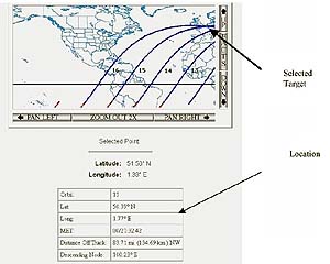 During a mission, the students use interactive Web pages to target and select whatever
parts of Earth they wish to capture in pictures. The orbit propagation program helps the
students select the Earth location the shuttle will be in at picture-taking time. A handy
orbit map allows students to click on a location the shuttle will pass over during the
mission (Figure 1). The software verifies that the target selected will be
available to the camera during that orbit. If an invalid target is selected (the location is not
viewable by camera or the shuttle is not at that location), the student receives immediate
notice and can then make another selection. A valid target will cause the program to
display such information as the orbit, latitude and longitude, and Mission Elapsed Time
(MET). The MET is the most significant data point since it defines the exact time the
shuttle (hence camera) will be positioned over the target selected. At the selected MET,
the camera will snap the picture.
During a mission, the students use interactive Web pages to target and select whatever
parts of Earth they wish to capture in pictures. The orbit propagation program helps the
students select the Earth location the shuttle will be in at picture-taking time. A handy
orbit map allows students to click on a location the shuttle will pass over during the
mission (Figure 1). The software verifies that the target selected will be
available to the camera during that orbit. If an invalid target is selected (the location is not
viewable by camera or the shuttle is not at that location), the student receives immediate
notice and can then make another selection. A valid target will cause the program to
display such information as the orbit, latitude and longitude, and Mission Elapsed Time
(MET). The MET is the most significant data point since it defines the exact time the
shuttle (hence camera) will be positioned over the target selected. At the selected MET,
the camera will snap the picture.
The UCSD MOC always verifies the integrity of a request before passing it, via the NASA link, to the computer connected to the camera. Also, the MOC eliminates duplicate selections, thus avoiding redundancy. Because the camera operates only in the visible light bands, it is important to note that since each orbit is 90 minutes, the shuttle will be in daylight only 45 minutes per orbit.
Once the pictures are taken, they are stored and compressed for transmission back to the UCSD MOC. They are then converted to JPEG and GIF formats for easy retrieval via a standard Web browser over the Internet (see http://www.earthkam.ucsd.edu, and click on "data system"). Pictures usually appear on the EarthKAM Web site within hours of being taken. The delay is due to communications bandwidth availability and the need to "batch up" enough pictures to transmit back to the UCSD MOC.
Imagine the thrill students feel when they use these images for classroom projects involving science, geography, mathematics, and space science. As a side benefit, these projects help develop students' skills in investigation and image analysis, while painlessly teaching them to navigate the Internet. During the first four missions, students took some 2,000 high-resolution pictures of Earth. What we have is the beginning of an historical record of the Earth via images that subsequent generations can use to see what has happened to our planet over time.
The Education Divisions of the NASA Field Centers identify schools for participation in an EarthKAM mission and organize them based on school/division interest, educational technology, experience, and commitment. (For more information see http://www.nasa.gov.) Although each participating school adapts its projects to local opportunities and priorities, there are three universal components of EarthKAM:
- Working with images of Earth. A wealth of images is available to support extended classes in subjects such as Earth science, mathematics, geography, social studies, math, communications, and art. Teachers and students use the EarthKAM Web site to search and access those images needed for their investigations.
- Designing and conducting investigations. Here is a unique opportunity not only to participate in the space program, but also to conduct first-hand scientific investigations. Some investigations already underway are exploring human settlement patterns, mountain ranges, and even agricultural patterns. Participating schools must submit a proposal outlining their intended overall project; from this they will later select targets pertinent to their specific project.
- Setting up a Student Mission Operations Center (SMOC) and targeting during the mission. Normally there is one, sometimes two, EarthKAM missions per year. Schools must establish the SMOC from which they will access the EarthKAM web site during the mission. The SMOC's functions are:
- to communicate with other SMOCs and EarthKAM personnel;
- to obtain the latest weather information;
- to track the shuttle's orbit; and
- to select and submit targets.
Before the mission, some training is needed (10-15 hours) to learn the procedures required for targeting and for working with the images once they are posted to the Web site. During the mission, students and teachers are often at the SMOC round-the-clock while the camera is operational (the camera is not constantly mounted during the mission).
The combined NASA Education Program and the EarthKAM program provide an example of government and education joining to support national- and state-based science, geography, and technology standards. Teachers and students gain first-hand experience in developing observation skills and real-life inquiry approaches. Coupled with this is the opportunity for developing teamwork and communication skills not only within the school they attend, but also among schools participating in the mission.
Much is said about how advantageous the Internet can be to a student's education. EarthKAM is an example of a positive use of the Internet to bring a dynamic distant learning experience to thousands of students. It's interactive, it's almost real-time, it has constantly-changing and captivating variables, and it challenges students to make decisions that are time-dependent. The EarthKAM experience is one that will stay with the participating students forever.
word gamespc gamesbrain teaser gamesbrick bustermatch 3 games